As the water crisis escalates, sustainability managers are tasked with measuring, reporting, and responding to water risks. However, another crisis is happening simultaneously and compounding their efforts—the “water data crisis.” This crisis involves the intricate and time-consuming task of gathering high-quality water data to assess and manage water risks effectively.
This article will explain the water data crisis concept and provide valuable insights to enhance your water risk management process. In this article, you will learn:
What we mean by the “Water Data Crisis”
The types of data required for comprehensive site water risk assessments
How sustainability managers cope with the water data crisis today
How technology and AI can help you tackle this challenge
What Is The Water Data Crisis?
Making informed decisions around sustainable water management depends on the timely availability of high-quality water risk data, which by definition needs to be granular, updated, and evidence-based. High-quality data enables sustainability managers to understand water risks and opportunities, identify risk mitigation responses, invest at the right time and place, report accurate information, and measure the impact, ultimately achieving their sustainability goals.
However, accessing high-quality water data is difficult:
Data is not readily available. Due to geographical, technological, or proprietary limitations, sustainability managers can’t easily access local water data at a global scale. This becomes more difficult as the number of facilities and regions in which a company operates increases.
The granularity and accuracy of available data are insufficient. Water risk is a local issue, so making informed decisions requires granular, evidence-based local data. However, the data that we can easily access is usually at a high level, lacking the geospatial and temporal dimensions needed. The risk with using this data is making misguided investment decisions and allocating resources in places that may be better allocated elsewhere.
Hundreds of data sources are required. Assessing scarcity, quality, flooding, regulatory, infrastructure, and reputational risks requires multiple external and internal data sources, all of which come in different formats and timelines.
Water expertise is needed. Technical expertise is usually required to understand and structure water data for decision-making.
As a result, sustainability managers and their teams spend significant time gathering, consolidating, and analyzing data, which is usually not at the granularity and accuracy required to ensure the right business decisions are made and accurate information is reported.
This is what we call the “Water Data Crisis”: the lack of reliable, comprehensive, and accessible data on freshwater resources that hinders effective water risk management and diverts attention from what matters most—taking action on water risk.
Understanding The Types of Water Risk Data
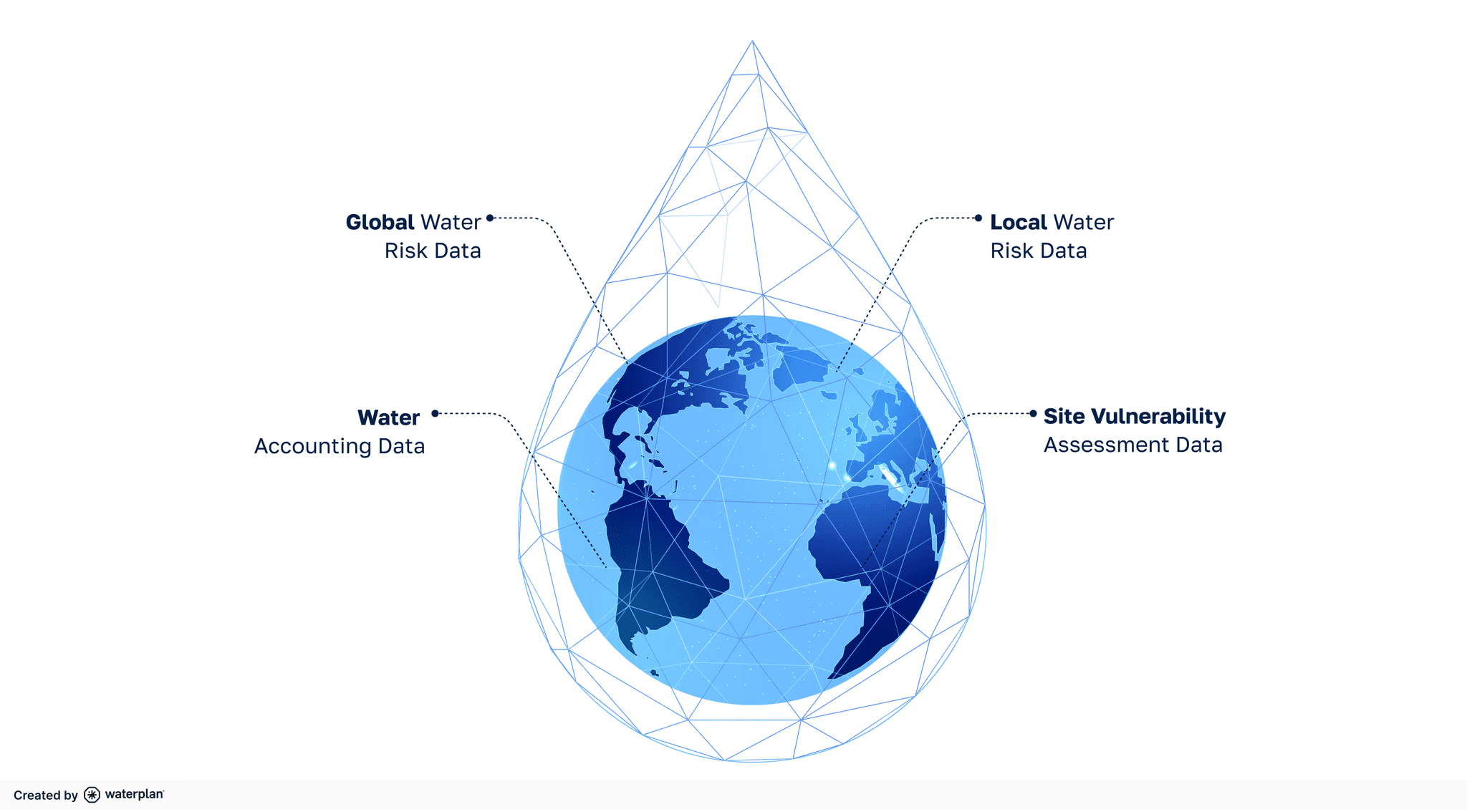
To tackle the water data crisis, it’s important to understand that there are four different types of data that when integrated, can provide a comprehensive understanding of local water risks:

Global Water Risk Data
This is a type of external data that measures the water risks your business can be exposed to, such as water scarcity, quality, flooding, infrastructure, reputational, and regulatory risk. It's essential to assess risks on a macro scale and benchmark your facilities against global averages. This data provides a general idea about which sites may have higher risks and what those risks are.
For example, NASA’s GRACE satellite is a data source that measures the change in total water storage in a particular region over time. This information can be used for identifying the regions worldwide that are gaining or losing groundwater. Similarly, the Global Flood Awareness System (GloFAS) River Discharge Data provided by the European Space Agency (ESA) tracks river discharge globally. It allows us to identify periods of abnormally low or high flows, which are critical for assessing scarcity or flooding situations.
Local Water Risk Data
The information gathered through global data is usually not granular enough. Understanding site-specific challenges requires local data, such as government meteorological and hydrological datasets, water quality reports, water usage statistics, and regulatory compliance records. This information is available from local government agencies, water utilities, and environmental monitoring stations. Local data provides additional context, ensuring that water risk management strategies are relevant and effective for each site.
For example, we can leverage locally observed streamflow data to identify flood or drought-like conditions.
Site Vulnerability Assessment Data
This type of internal company data helps determine a facility’s susceptibility to water risks. Some facilities may have robust water management plans to cope with different types of water risks, while others may not. Moreover, some sites may have experienced water risks, such as scarcity, but the external data may indicate something different. By gathering vulnerability data, sustainability managers can better understand which sites are more vulnerable to water risks and leverage this information when prioritizing where to take action.
For example, data such as previous drought or flooding events experienced, current water management plans, and water priorities can be gathered as part of the vulnerability assessment data.
Water Accounting Data
Finally, another type of data that needs to be measured is water accounting data, which includes water consumption, discharges, costs, and associated revenue. This data is collected from internal systems, water meters, and local suppliers. It is crucial for understanding water efficiency and identifying opportunities for improvement.
How Do Sustainability Teams Address The Water Data Crisis Today?
Sustainability managers and their teams usually rely on a combination of methods and tools to gather these data sources and measure water risks. The following are common examples:
To gather external water risk data, many rely on open-source tools or consulting firms for more tailored insights. However, incorporating local water risk data into this analysis becomes extremely difficult when many sites are involved. As a result, local data is either not gathered or is inconsistent for all sites, which complicates the initial water risk assessment and prioritization.
To compile vulnerability assessment data, sustainability managers usually distribute forms and spreadsheets across regional and facility teams. This usually requires significant back-and-forth communication, and the data gathered across sites is often not standardized, requiring additional time to analyze it.
Water accounting data is usually sourced from a company’s internal systems. However, a common problem with this data is that the format and timeline don’t easily fit with the other datasets collected and analyzed by the team. Additionally, sometimes, this data is only available through utility bills and not centralized in an internal system.
External and internal data sources are manually consolidated, usually in another spreadsheet. Due to the data's complexity and volume, sometimes IT teams' help is required. This process is time-consuming and can be prone to errors.
The Opportunity of Technology & AI
In response to the water data crisis and the associated challenges in water management, innovative solutions are leveraging advanced datasets and AI technologies to provide comprehensive tools for measuring, reporting, and responding to water risks effectively. These solutions remove the need to gather, consolidate, and analyze data manually, enhancing the accuracy of the information, saving time, and helping you easily scale the analysis and decision-making.
With these solutions, you can:
Collect high-quality global and local water risk data
By leveraging AI and machine learning, multiple global and local data sources can be measured and integrated to provide a comprehensive, granular, and evidence-based understanding of external water risks. For example, data sources that can be gathered include satellite imagery, hydrological model outputs, local government databases, and local public reports. Furthermore, AI-based regional hydrological models can provide an additional layer of accuracy and predictive capability to the existing datasets.
Simplify the process for gathering internal data
Water risk management technology solutions can streamline gathering site vulnerability data and eliminate the need to leverage multiple formularies and spreadsheets. Moreover, you can integrate water accounting data from your operational systems to provide a holistic view of your water management processes across facilities.
Consolidate & visualize water risk at a local, regional, and global level
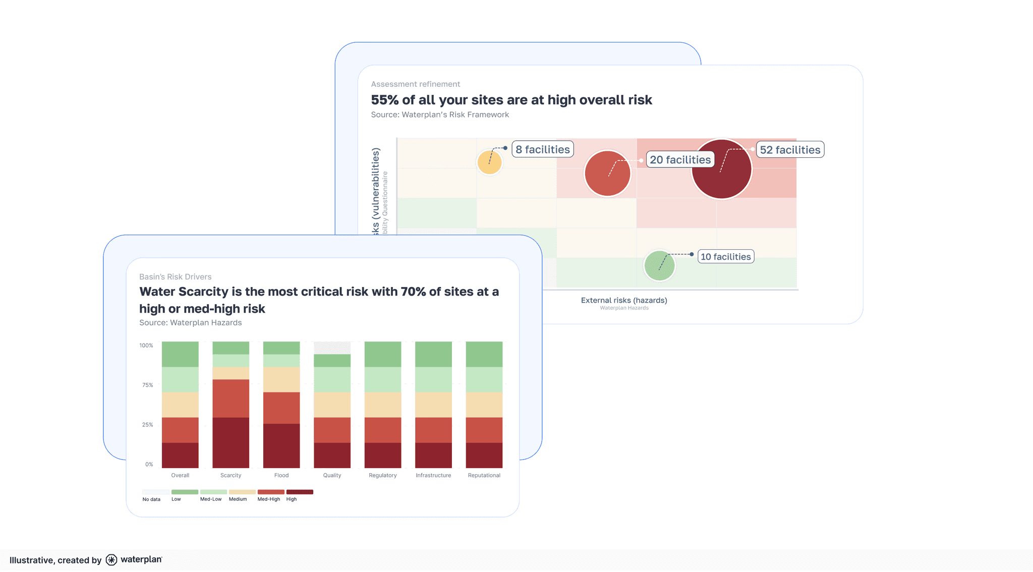
Technology solutions integrate and structure the external and internal data into different water risk indicators and assign them scores so you can visualize, compare, and prioritize sites with low, medium, or high water risk across different dimensions, including scarcity, quality, flooding, infrastructure, reputational, and regulatory risk.

Estimate water risk evolution
With sophisticated predictive analytics, historical water risk data and current trends can be analyzed to predict future water conditions and potential risks. This foresight enables businesses and communities to proactively implement measures that mitigate potential future risks.
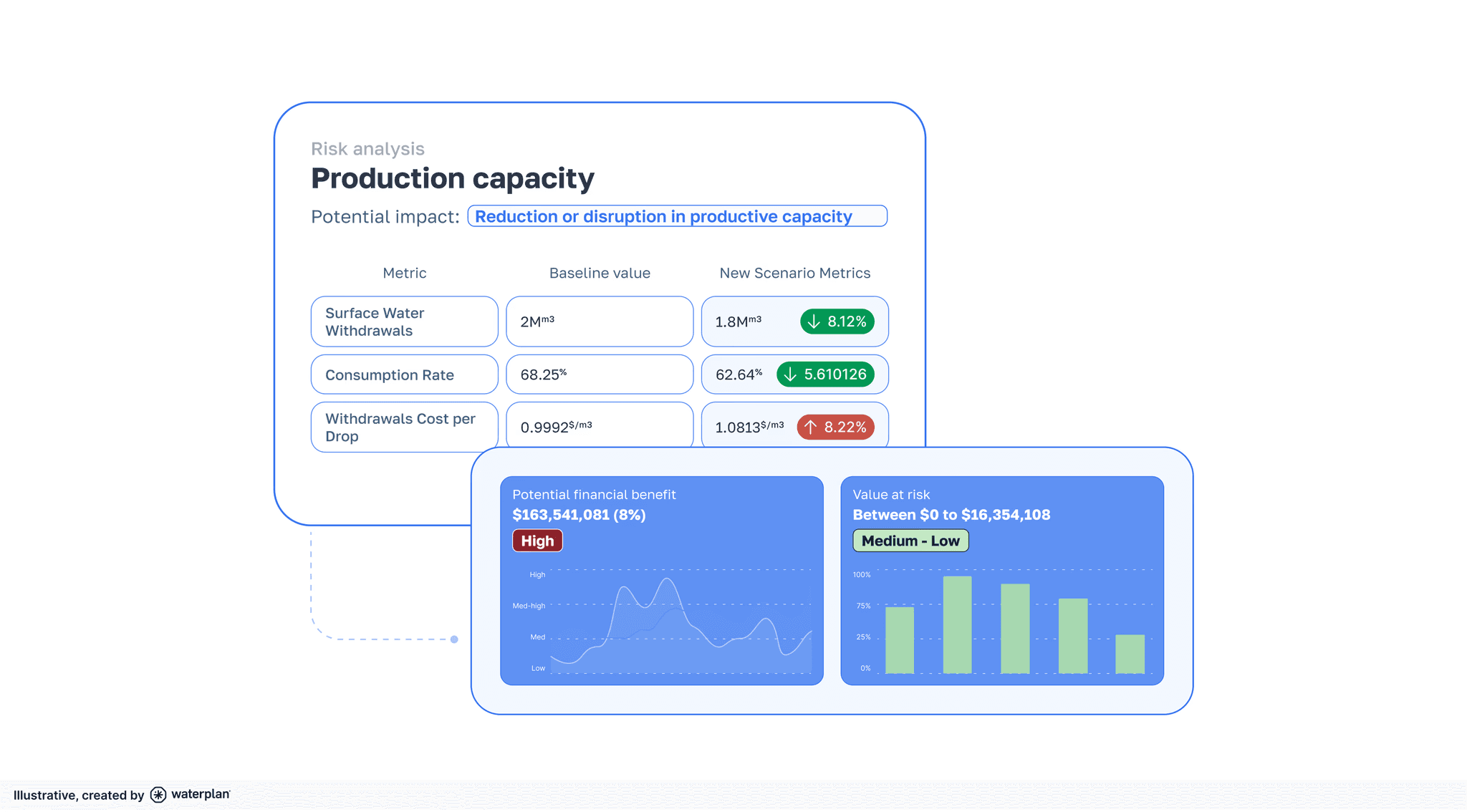
Quantify the value at risk and the return on investment (ROI)
Besides measuring water risk, technology solutions can quantify the financial impact of risks by using scenario analysis. This information can help estimate the return on investing in initiatives to mitigate water risks.

Conclusion
The water data crisis presents a significant challenge for sustainability managers, as the lack of high-quality, granular, and comprehensive water data hinders informed decision-making and timely action. However, advanced technology and AI play a pivotal role in providing a solution that automates water risk data collection, enhances data accuracy, and provides tools for risk assessment and prediction. By leveraging these solutions, sustainability managers can overcome the data barriers, enabling them to make more informed decisions, optimize resource allocation, and achieve their sustainability goals more efficiently and precisely.
Connect with us to learn how Waterplan can help you measure, report, and respond to water risks with technology and AI.
情報を常に把握しておいてください


